The map & replay
See where the drones are and what their cameras see, rewind the mission, watch past missions, and look at photos.
Open the map
There are two maps:
- In a pane: in any pane's drop-down, pick Map. Good for watching video and the map side by side. (Up to 2 map panes.)
- The full map page: in a Map pane, tap MAP ↗. It opens in a new
tab. Rewind, past missions, photos and recorded video are only on the
full map page. You can also go straight to
sarstream.org/telemetry/map.
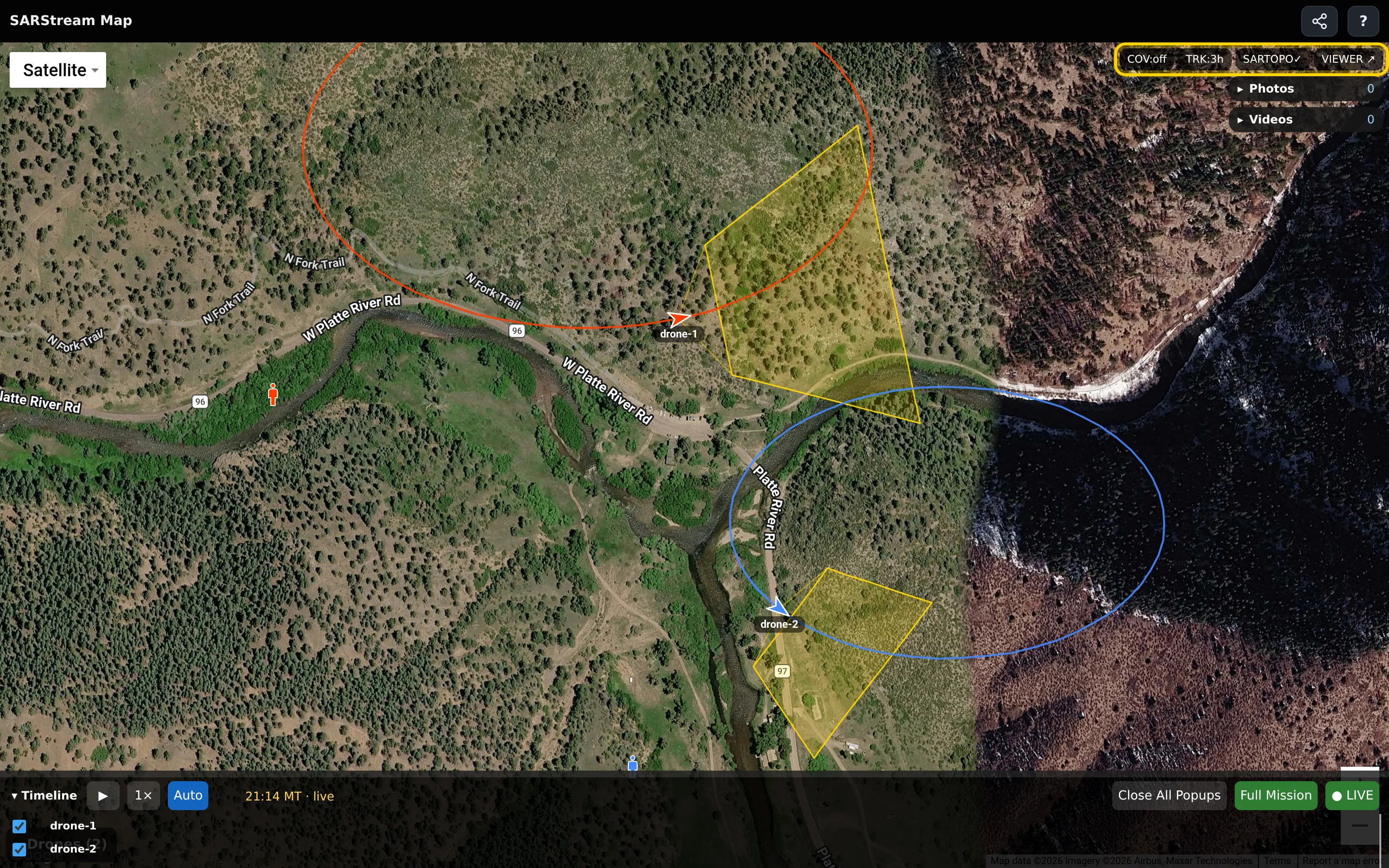
What's on the map
| You see | It means |
|---|---|
| A colored arrow with a name under it | A drone, pointing the way it is flying. Each drone gets its own color. It turns grey when its position hasn't updated for a few seconds. |
| A small person in the drone's color | Where that drone's pilot is. |
| A larger person with a wedge | A phone that is live (Go Live), and the way it is facing (approximate). |
| A yellow box with a faint cone | What the drone's camera can see on the ground. It follows the camera's zoom. |
| A line behind a drone | Where it has flown. TRK sets how long the line is. |
| 📷 dots | Drone photos. Red means marked as a clue. Tap one to open the photo. |
| Colored shapes and labels | Your team's SARTopo assignments, tracks and markers (if your agency uses SARTopo). |
A drone that hasn't been seen for an hour leaves the map.
Tap a drone for its details: battery, height, speed, heading, camera, and how old its last position is.
The Drones list at the bottom left (tap ▸ Drones) lists every drone on the map.
Map buttons
| Button | What it does |
|---|---|
| COV | Coverage: shades the ground the cameras have already seen. Tap to change the time window (15 minutes up to the whole mission). Off by default. |
| TRK | Length of the drone trails. |
| SARTOPO | Shows or hides the SARTopo shapes. |
| MAP ↗ / VIEWER ↗ | Opens the full map page / the video viewer in a new tab. |
Rewind (full map page)
The timeline runs along the bottom of the full map page. Each drone has a row: blue bars are recorded video, diamonds are photos. On a narrow screen, tap ▾ Timeline to open it.
- Drag along the timeline (or tap a spot) to go back in time. The drones move back to where they were, and recorded video opens in small windows.
- Tap ▶ to play. Change the speed with 1×.
- To return to live, tap Go Live on the timeline (it shows ● LIVE when you are live). This button only moves the timeline — it is not the phone Go Live.
While you are rewound, a red Not Live — bar shows the time you are looking at.
smoke test flight, or a training mission)Past missions (full map page)
- On the full map page, open the mission picker (it says Mission: current).
- Pick a past mission. The map shows its tracks, and the timeline starts at its first flight.
SARTopo shapes for a past mission come from the SARTopo map as it is now, not as it was then. If the map was deleted, there are no shapes.
Missions your admin hid don't appear. A mission that was not recording has no recorded video to replay.
Photos and recorded video (full map page)
- ▸ Photos lists the mission's drone photos. Tap one to open it. In the photo window: pinch or scroll to zoom, 📍 shows where it was taken, ⤓ downloads it, ✕ closes it.
- ▸ Videos lists each flight's recording. Recording runs a few minutes behind live — the newest few minutes appear shortly.
In a replay video window, ⤓ downloads the flight, and SYNC✓ keeps the window in step with the timeline. If a window says no video at this time, there was no recording at that moment — drag to the next blue bar.